Using remote sensing and Anthesis UMR's proprietary technology DRYSATMAP® to tackle the challenges of tracking climate change impacts
There has never been a time like now when we need to sharpen our focus on the natural environment.
But the rules have changed. Forever.
The historical convention has been oriented around evaluating the impact of business on nature. However, recent extreme weather and natural disaster events have highlighted that we ignore the impact of nature on business, and society in general, to our peril.
As we all know, climate change is a global phenomenon that requires “big picture”, long term thinking which demands businesses and governments alike to make decisions based upon complex and often changing circumstances, information and data. It’s perhaps no surprise that against such a dynamic background, the world of commerce and civil administration has been challenged to formulate concrete policies and plans.
Let’s not forget that while climate change requires many of our societies and businesses to adapt to new circumstances, for many it represents phenomenal commercial opportunity.
We can help you take those hard-to-make decisions, build resilience, and realize opportunity.
With a thirty year archive of multi-spectral satellite imagery at our fingertips, the data of the past is the key that unlocks the future. We can track and demonstrate physical changes that are relevant to your business, your real estate assets, your water resources, your agricultural production, etc. We can show you where the challenges lurk – and where opportunities remain hidden and untapped. We can help you align your infrastructure to avoid future geo risks; highlight where vegetation change is an indicator of a shifting groundwater regime; show changes in sediment deposition to ensure that your port facilities remain navigable. And in arid and semi-arid climates, we can also help you identify mineral deposits in both rocks and sediments.
How can satellite imagery help?
Many people use Google Earth (below left) for satellite views. However, the value that can be gleaned from the use of sophisticated and empirically calibrated tools, such as Anthesis UMR’s proprietary DRYSATMAP® (below right) is quite distinct:
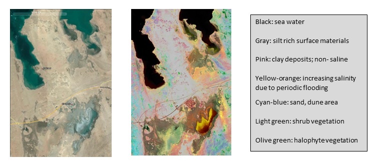
Empirical calibration is critical; we build certainty by ensuring that we know what each color (determined using multi-spectral analysis) represents. We can fingerprint change: accurately and robustly.
The outcomes and financial benefits of using such technology are clear from some of the work we’ve delivered for our clients. Please check out our case study examples.
If you would like to learn more, or request a web demonstration, please contact Wolfgang Wick (wolfgang.wick@anthesisgroup.com) at Anthesis UMR. You can also read some of our case studies which can be accessed via the links in the text above or as listed below:


